Winter Storm Fern Puts South and East on Alert as Snow and Ice Threaten Millions
A major winter storm is poised to disrupt large parts of the southern and eastern United States this weekend, bringing the potential for heavy snow, damaging ice and widespread travel and power impacts. Named Winter Storm Fern by The Weather Channel, the system is expected to affect millions of people from Texas and Oklahoma through the Southeast, Appalachians and into the Mid Atlantic and Northeast.
For regions that rarely experience prolonged winter weather, the storm could pose significant challenges to infrastructure, transportation and daily life.
Meteorologists stress that while some forecast details may still shift, the overall setup strongly supports a broad and impactful winter event. Residents across the South and East are being urged to monitor forecasts closely and prepare for rapidly changing conditions from Friday through Sunday.
A Rare and Widespread Southern Winter Threat
Winter Storm Fern arrives just days after parts of the South experienced snowfall last weekend, underscoring a pattern of unusually active winter weather for the region. What makes this storm especially notable is its potential geographic reach.
Snow, sleet and freezing rain are all expected across multiple states that typically see more rain than ice during winter systems.
Forecasters say the combination of cold air and incoming moisture creates conditions favorable for both significant snow accumulation and dangerous ice buildup. In areas where freezing rain dominates, even modest amounts of ice can lead to hazardous roads, downed trees and power outages that may last for hours or even days.
Timing and Evolution of the Storm
The winter weather is expected to unfold over several days, beginning in the Southern Plains and expanding eastward as the weekend progresses.
Friday: Southern Plains and Lower Mississippi Valley
By late morning or early afternoon Friday, snow, sleet and freezing rain are forecast to increase across parts of Oklahoma and northern and western Texas. The wintry precipitation may also extend into Arkansas and possibly reach western Tennessee and northern Mississippi.
Cities that could see early impacts include Lubbock, Oklahoma City, Tulsa, Little Rock and Memphis. Travel conditions in these areas may deteriorate quickly as temperatures fall and precipitation intensifies.
Friday Night: Expansion Into the Tennessee Valley and Appalachians
Friday night, the storm is expected to sag southward while also spreading east into the Tennessee Valley and Appalachian region. A mix of snow, sleet and ice is likely across a broad area, with precipitation potentially reaching parts of Virginia and the Carolinas.
Cities such as Dallas, Austin, Shreveport, Nashville, Huntsville, Asheville and Charlotte may begin to see accumulating winter precipitation overnight, raising concerns for early Saturday travel.
Saturday: Deepening Impacts Across the South and East
On Saturday, wintry precipitation could sink farther south into Texas, Louisiana, Mississippi and Alabama. At the same time, snow and ice are expected to increase across Kentucky, Tennessee, West Virginia, Virginia and portions of the Carolinas.
This phase of the storm may affect a wide range of cities, including San Antonio where impacts remain uncertain, along with Knoxville, Raleigh, Greenville Spartanburg, Roanoke and Richmond.
Conditions may vary sharply over short distances, with snow in some areas and freezing rain or sleet in others.
Saturday Night: Intensification and Northeast Reach
Saturday night appears to be a critical period. The storm may push even farther south toward parts of the Texas Gulf Coast, southwestern Louisiana and northern Georgia, while snow spreads into the Mid Atlantic and intensifies in some areas.
Major metropolitan areas potentially impacted during this time include Atlanta, Washington DC, Baltimore, Philadelphia and New York City. In these regions, the timing and intensity of snowfall could significantly affect weekend travel and operations.
Sunday: Gradual Improvement in the West, Lingering Impacts Elsewhere
By Sunday, wintry precipitation is expected to taper off in Texas but continue from parts of Louisiana through the Tennessee Valley, Appalachians, Carolinas and into the Northeast.
Some areas of the East could still see heavy snow before conditions gradually improve later Sunday or Sunday night.
Forecasters caution that it remains unclear whether all areas will see a complete end to precipitation by Sunday night or if lingering effects could extend into Monday.
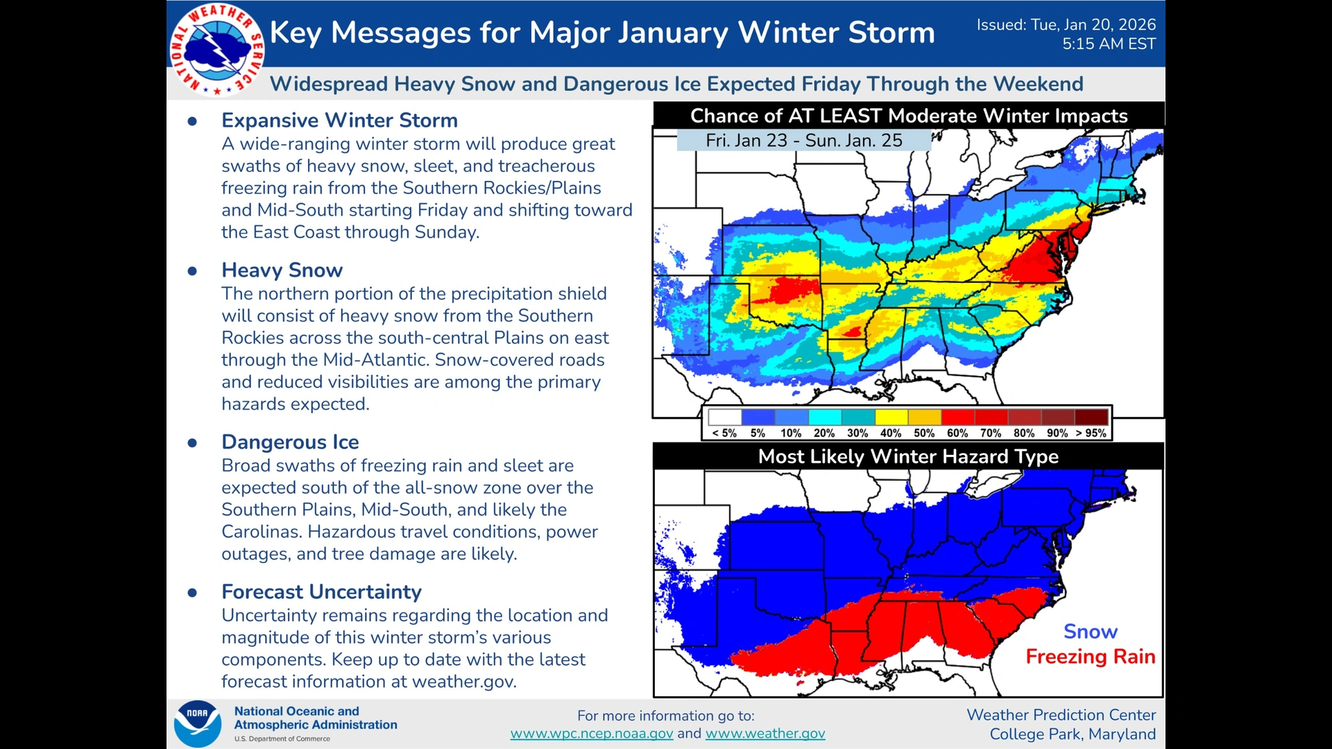
Ice Accumulation a Major Concern
While snowfall often draws the most attention, meteorologists emphasize that ice may pose the greatest risk during Winter Storm Fern. Forecast maps indicate a broad swath of the South could experience significant ice accumulations from parts of Texas through the Carolinas.
Even relatively small amounts of freezing rain can coat roads with a slick glaze, making travel hazardous or impossible.
Ice accumulating on trees and power lines increases the risk of branches snapping and lines failing under the added weight.
Snowfall Potential Across a Broad Corridor
It remains too early to provide precise snowfall totals, but forecasters indicate that a large corridor from northern Texas and Oklahoma through the Mid Atlantic could see meaningful snow accumulations between Friday and late Sunday.
Areas with the highest likelihood of heavy snow may also experience sleet at times, further complicating travel conditions.
For northern cities accustomed to winter weather, the storm could still bring disruptions depending on snowfall intensity and timing.
The Atmospheric Setup Behind Winter Storm Fern
Meteorologists point to a classic winter weather setup that increases confidence in widespread impacts.
Arctic High Delivers Cold Air
One key ingredient is a strong Arctic high pressure system expected to settle over the Great Lakes by the end of the week.
This system will funnel cold air southward, driving temperatures down across much of the southern United States.
As cold air pushes into regions that typically remain above freezing, the risk of snow and ice increases dramatically when precipitation arrives.
Southwest Storm Brings Moisture
At the same time, a storm system developing in the Southwest will move eastward, drawing moisture northward ahead of it.
This moisture is expected to fall initially as rain across parts of the South earlier in the week.
As temperatures drop under the influence of the Arctic high, that rain is forecast to change over to freezing rain, sleet or snow depending on local conditions.
Cities and Communities on Watch
The list of potentially impacted cities is extensive and includes many major population centers.
From Houston and Dallas to Atlanta, Charlotte and Washington DC, millions of residents may face travel disruptions and weather related hazards.
In the Northeast, cities such as New York City, Philadelphia, Baltimore and Boston could see snow later in the weekend, adding to the storm’s broad reach.
Why This Storm Matters
Winter Storm Fern highlights the vulnerability of southern infrastructure to cold weather events.
Power grids, road networks and emergency services in many parts of the South are not designed for prolonged ice and snow, increasing the risk of cascading impacts.
For travelers, the storm could disrupt air and ground transportation across multiple regions simultaneously.
Staying Informed as the Forecast Evolves
Forecasters caution that there is still some uncertainty regarding exact precipitation types and amounts in specific locations.
Small shifts in temperature or storm track can make the difference between rain, ice or snow.
As a result, residents across the South and East are encouraged to stay informed through reliable weather updates as the weekend approaches.

Edit Profile
Help improve @KR

Was this page helpful to you?
Contact Khogendra Rupini
Are you looking for an experienced developer to bring your website to life, tackle technical challenges, fix bugs, or enhance functionality? Look no further.
I specialize in building professional, high-performing, and user-friendly websites designed to meet your unique needs. Whether it’s creating custom JavaScript components, solving complex JS problems, or designing responsive layouts that look stunning on both small screens and desktops, I can collaborate with you.
Create something exceptional with us. Contact us today
Open for Collaboration
If you're looking to collaborate, I’m available for a variety of professional services, including -
- Website Design & Development
- Advertisement & Promotion Setup
- Hosting Configuration & Deployment
- Front-end & Back-end Code Implementation
- Code Testing & Optimization
- Cybersecurity Solutions & Threat Prevention
- Website Scanning & Malware Removal
- Hacked Website Recovery
- PHP & MySQL Development
- Python Programming
- Web Content Writing
- Protection Against Hacking Attempts